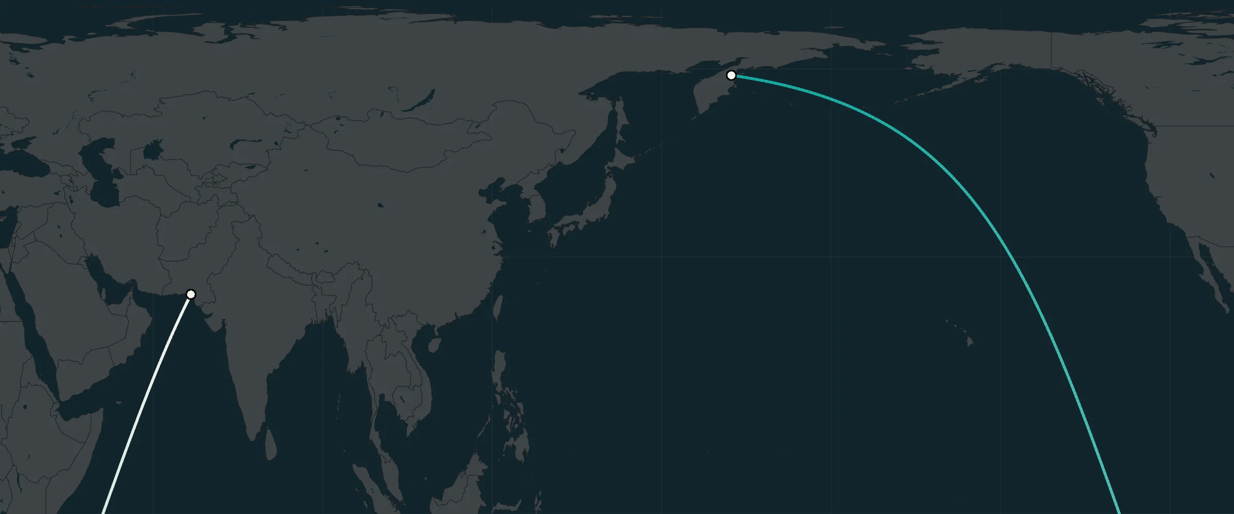
People are still surprised that a straight line on a globe looks curved on a flat map. A few years ago, a picture of a route from India to Alaska was making the rounds online. On the map, it makes a huge loop: it heads south, rounds Africa and South America, then heads north to Alaska.
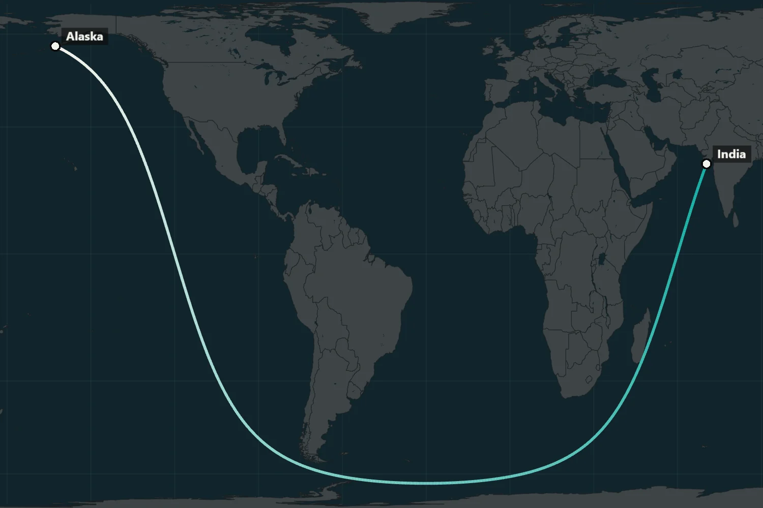
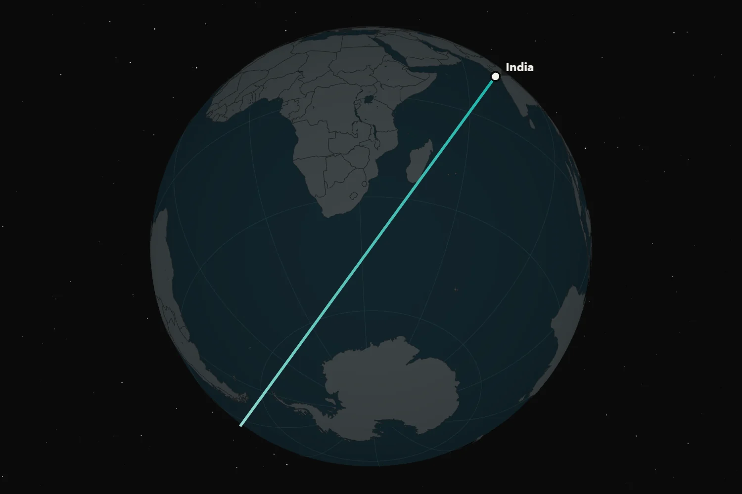
On a globe, it is a straight line 29,747 km long: you can sail along it from the coast of Gujarat to Alaska without touching land. You can follow it without turning, although your compass heading will change along the way.
I wanted to see these straight lines for myself: where they lead from different countries and points, how far you can walk over land or sail over water, and where the shortest routes by air actually go.
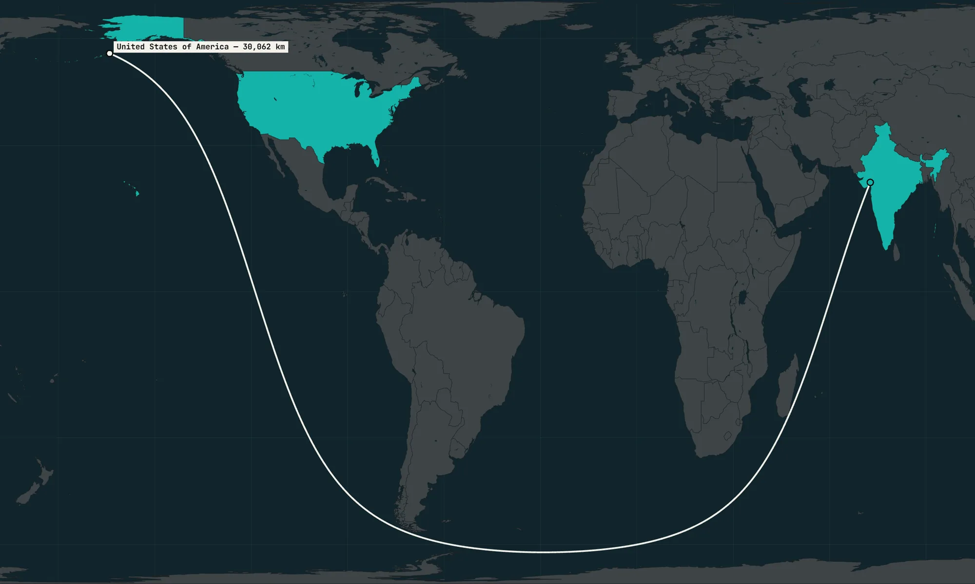
I made a map and started by checking that picture. It turned out there is a slightly longer straight line by sea between India and the USA: 30,062 km. I searched the entire coastlines of both countries, while the route in the picture starts at one point in Gujarat.
Then I connected the airports in New York and Singapore by air. The world’s longest scheduled non-stop flight runs between them. The shortest route passes just 280 km from the North Pole, then over Siberia and China.
I wanted to see all directions at once, as well as individual pairs of countries. From Spain, straight lines by sea fan out to neighbouring Portugal and Morocco, across the ocean to North and South America, and to northern Europe.
From a point near New York, the lines cross the Atlantic towards Europe, West Africa and Brazil. One goes around the south of Africa and reaches Australia: 21,191 km across open water. The point itself is 58 km from the nearest land.
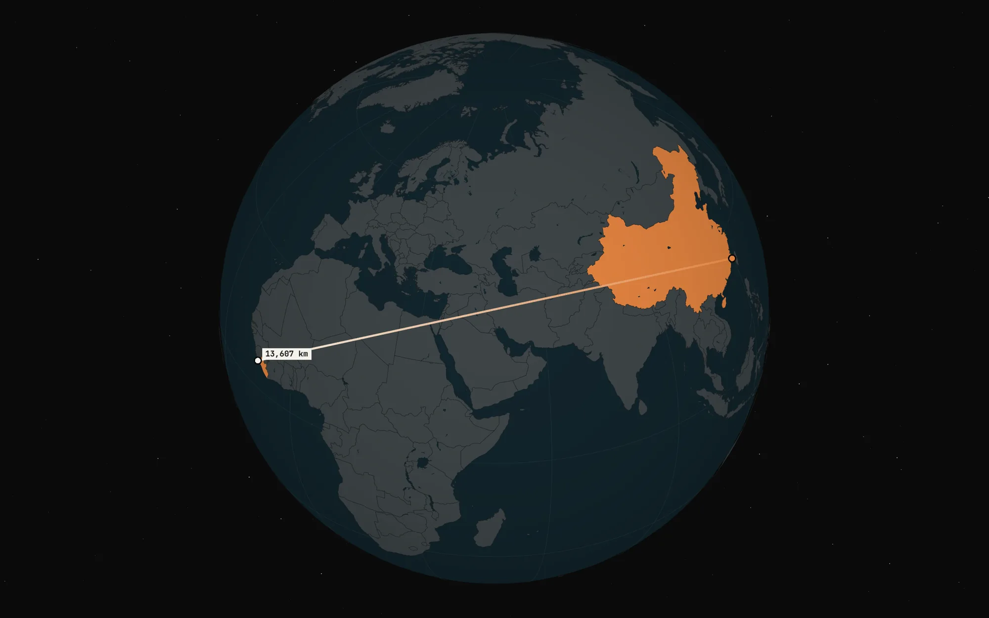
The longest straight line over land runs from China to Liberia. It is 13,607 km long. Along the way, it passes 3 km from the southern tip of the Dead Sea. You have to cross the Suez Canal on this route: I did not count it as sea in this calculation.
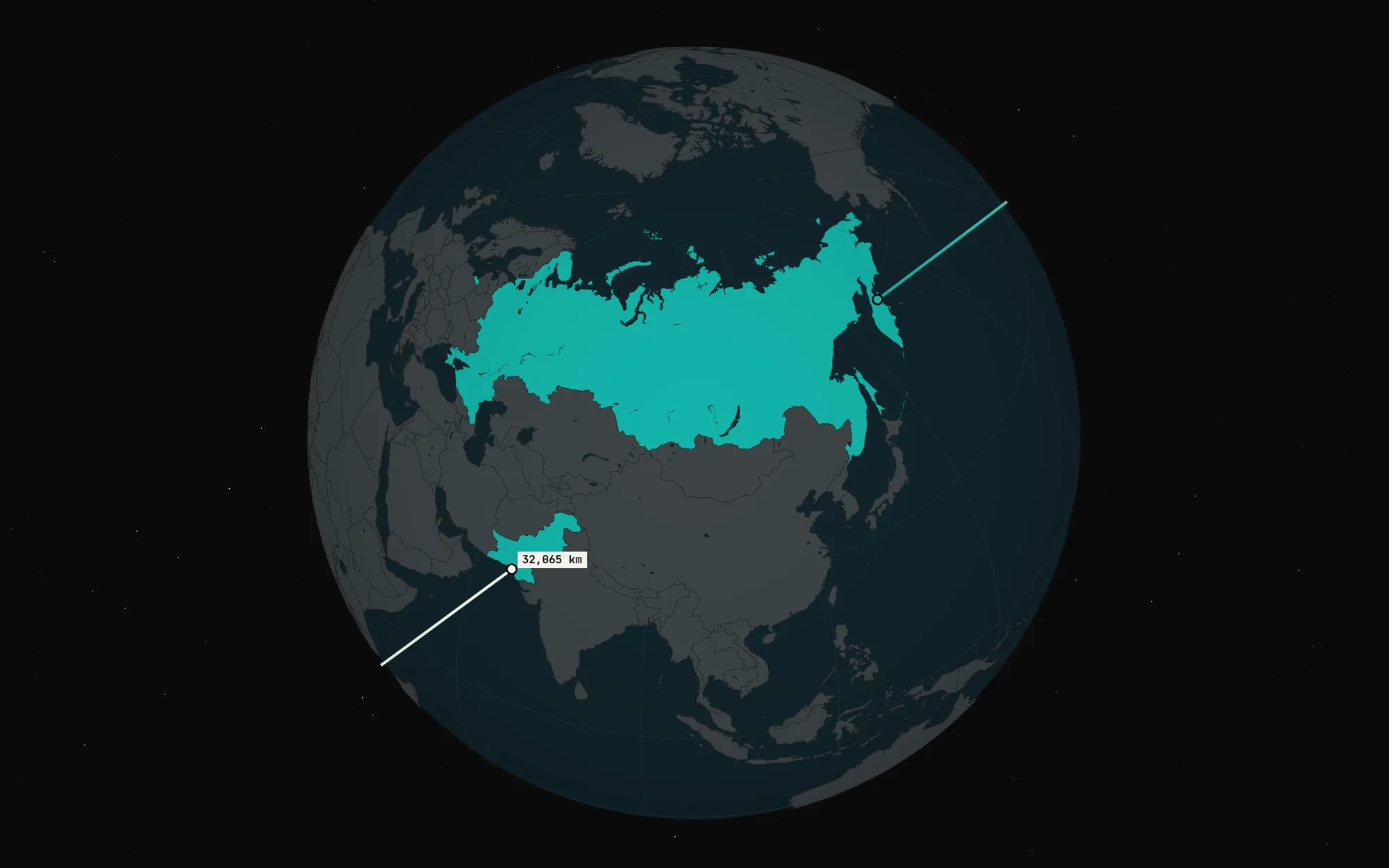
By sea, the record is longer still: 32,065 km from Kamchatka to Karachi in Pakistan. That is four fifths of Earth’s circumference, and longer than the route from India to Alaska in the picture.
I also found the point in the Atlantic farthest from land. Its Pacific cousin has a well-known name, Point Nemo, while the Atlantic one had none. I called it Point Vova. Who’s going to stop me? The nearest land is 2,034 km away, and three shores lie at that distance: Flores in the Azores, La Désirade off Guadeloupe and Santo Antão in Cape Verde.
The result is the Straight Line map. You can use it to find your own straight lines between countries or points and see where lines drawn in different directions from one place will take you.
Straight lines on Earth. Earth is slightly flattened at the poles, so I used the WGS84 ellipsoid for the calculations, the same model that GPS uses. A straight line on it is a geodesic: it goes without turning, and the shortest path between two points follows such a line. On a sphere, it would close into a great circle, like the equator. On an ellipsoid, after going around Earth, it usually passes near its starting point without going through it. I calculate the lines using Charles Karney’s formulas.
By water, a straight line runs from shore to shore without touching land anywhere along the way. Straight lines across large lakes count too.
By land, a straight line runs from country to country without touching the sea. Seas and the Caspian always count as water. Separate layers let you add lakes and reservoirs of 1,000 km² or more, along with the Dead Sea; the Suez and Panama canals; and the major permanent rivers from WDBII, including their wide sections and lakes.
A line between two countries is measured from where it leaves one to where it enters the other. For neighbouring countries, that is 0 km.
By air, nothing stops a straight line. Between countries, it is the shortest path between their outlines on the map. The farthest point from a country is the one whose distance to the country’s nearest edge is greatest. The farthest point from a point is its antipode, 20,004 km away.
I determined the air records by the average distance from a country to all the others. For this, I used its mainland or main island, without its overseas territories.
Data. For coastlines and lakes, I used GSHHG 2.3.7 at full resolution; for rivers, the WDBII database from the same dataset. For country calculations, I used Natural Earth 5.1.2 borders at 1:10m scale, and for drawing the map, 1:50m. Regions and provinces use the 1:10m data; island and peninsula names also come from Natural Earth.
Country borders tell me whose land a straight line starts and ends on. Exclaves and islands more than 250 km from the rest of a country’s territory count as separate parts. You can draw lines from the whole country or just from a piece of land you select with a tap.
Changes to the data. Russia is shown within the borders set by Federal Constitutional Law No. 6-FKZ of 21 March 2014 and Federal Constitutional Laws Nos. 5-FKZ, 6-FKZ, 7-FKZ and 8-FKZ of 4 October 2022*. The Donetsk and Luhansk People's Republics and the Zaporizhzhia and Kherson oblasts were assigned to Russia using their Natural Earth borders. Baykonur, which is shown separately in that dataset, was assigned to Kazakhstan.
The edge of Antarctica’s ice shelves counts as its coast. I used Natural Earth to assign stretches of the GSHHG coastline to countries: each stretch belongs to the country that covers it. A small island missing from Natural Earth belongs to the nearest country on the same landmass.
In GSHHG, the canals cut through the land, separating Africa from Asia and North America from South America. I filled those gaps with land and kept the canals as a separate layer.
Country tables. For the tables, I spread 4,000,000 geodesics evenly over Earth. On average, neighbouring lines are about 8 km apart. Each line is traced once around Earth through every coastline segment it crosses, using vectors instead of a raster, with metre precision.
For each pair of countries, I kept the longest and shortest straight lines found. I then refined the longest straight line from each part of each country, shifting and rotating it a little at a time for as long as its length increased.
Straight lines from a point. Lines from a point are calculated in the browser using the high-resolution GSHHG coastline, which is a little coarser than the one used for the tables. Coordinates are rounded to 0,0001°, or about 11 m.
First, a ray is drawn at every degree. Each gap between neighbouring rays with different endpoints is then divided into ten. The refinement continues down to a step of 0,001°. That is why the fan of lines appears in waves.
Poles of inaccessibility. An oceanic pole of inaccessibility is the point at sea farthest from any land. I treated every vertex of the full-resolution GSHHG coastline as land, including islands and the edge of Antarctica’s ice. I divided the sea into quarter-degree cells and split it into oceans along the usual boundaries. I refined the best cell in each ocean with a local search, halving the step until it reached one metre.
Point Vova, the Atlantic’s pole of inaccessibility, is at 24,1852° N, 43,3709° W. The nearest land is 2,034 km away: the shores of Flores, La Désirade and Santo Antão all lie at that distance. I used OpenStreetMap coastlines for these three islands.
The land pole of inaccessibility is at 45,34° N, 88,25° E, 2,514 km from the sea. I found it the same way using the high-resolution GSHHG coastline.
Other work. In 2012, Reddit user kepleronlyknows posted a map of the longest straight line over water. In 2018, Rohan Chabukswar and Kushal Mukherjee checked it and found the longest straight lines over water and over land.
Their straight line by sea was 32,090 km, 25 km longer than mine. Over land, counting the Suez Canal as water, they got 11,241 km from China to Portugal; under the same rule, I got 11,266 km. They treated Earth as a sphere and took land and water from the ETOPO1 height map, with a resolution of about 1.8 km. On a sphere, my results would be 32,084 and 11,246 km.
For Point Nemo, the Pacific’s pole of inaccessibility, I give the commonly cited coordinates and distance calculated by Hrvoje Lukatela in 1992: 48,8767° S, 123,3933° W and 2,688 km to the nearest land. My search along the GSHHG coastline puts it 17 km farther south, 2,705 km from land: GSHHG lacks Maher Island off Antarctica.
Here are instructions for your robots: they can use them to reproduce the whole project. And here is a project description for language models.
Data & caveats
- GSHHG 2.3.7: coastline and lakes; rivers from WDBII. By Paul Wessel and Walter Smith, version dated 15 June 2017.
- Natural Earth 5.1.2: countries, borders, regions and provinces, island and peninsula names; May 2022 version.
- Federal Constitutional Law No. 6-FKZ of 21 March 2014: the Republic of Crimea and Sevastopol.
- Federal Constitutional Laws of 4 October 2022: No. 5-FKZ, No. 6-FKZ, No. 7-FKZ and No. 8-FKZ: the Donetsk and Luhansk People's Republics and the Zaporizhzhia and Kherson oblasts.
- Charles Karney, “Algorithms for geodesics”, 2013: formulas for geodesics on an ellipsoid.
- Rohan Chabukswar and Kushal Mukherjee's paper, 2018: calculations of the longest straight lines over water and over land.
- Guinness World Records: Point Nemo's coordinates and distance from land, calculated by Hrvoje Lukatela.
- OpenStreetMap: coastlines of the three islands nearest to Point Vova.
Lines from a point use a slightly coarser GSHHG coastline than the country tables, so the results may differ slightly.
Built with
WebGLthree.jsNuxt 3Vue 3Web WorkersPythonNumPyNumbaCloudflare Pages
This format can be adapted for a report, research project or editorial feature built around your data.