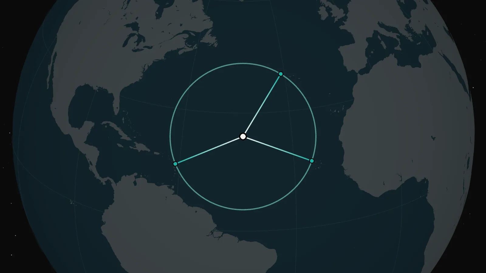
In the middle of the North Atlantic there is a point 2,034 kilometres from the nearest land. And that in three directions at once. Draw a circle of that radius around it and there won’t be a single island inside, not even the tiniest. Almost 13 million square kilometres of water, an area a little smaller than Antarctica.
This is the Atlantic pole of inaccessibility. Its coordinates have been known for several years, but it never seems to have got a name of its own.
I computed it while working on Straight Line, an interactive map that shows where you can sail in a straight line without meeting land. I started reading about poles of inaccessibility and found a curious thing.
The best known of the poles is Point Nemo in the Pacific. The survey engineer Hrvoje Lukatela computed it in 2002 and named it after the captain in Jules Verne’s novel. But in the English Wikipedia’s table the Atlantic pole is listed simply as Atlantic Ocean. The Russian version of the table doesn’t have it at all.
So there is no name. The coordinates are another story.
It turned out I was not the first. In 2019 the researcher Richard Barnes published a paper on the optimal orientation of discrete global grids. As a by-product, it gives new calculations of the poles of inaccessibility, the places farthest from any coastline.
Barnes recomputed the poles on a modern model of the Earth, using two independent sets of coastlines: GSHHG and OpenStreetMap. For the Atlantic he got two results about 834 metres apart.
With OpenStreetMap the coordinates came out as 24.1851° N, 43.3704° W, and the distance to land as 2,033.8849 kilometres.
That was already a serious and fairly precise calculation. What’s more, in the same paper Barnes refined the position of the famous Point Nemo: it turned out to be about 15 kilometres from the earlier coordinates.
I wanted to compare: to recompute my point just as carefully, on fresh data, and to find out exactly which shores fix its position.
In geometry’s terms, a pole of inaccessibility is the centre of the largest circle that fits in the ocean without touching land.
The Atlantic circle has three points of contact. They lie far enough apart that moving the centre anywhere shortens the distance to at least one of the shores.
The calculation needs two things: a coastline and a way to measure distances over the Earth’s surface.
With coastlines there is a choice. GSHHG, for one, is a global database of the outlines of all the world’s land. It is handy for a first search, but some small islands and rocks are missing from it. OpenStreetMap is far more detailed: volunteers map even single rocks in the surf.
A rough calculation on GSHHG gave the area and the three nearest islands. After that it was enough to take from OpenStreetMap the shores that face the point: on those three islands and on the two next nearest.
Distances have a catch too. The Earth is not a perfect sphere: it is slightly flattened at the poles. Precise measurements use the WGS84 ellipsoid. Treat the Earth as a sphere, and the Atlantic pole moves about 3.2 kilometres north.
In Python, with the GeographicLib library, you can measure distances on the ellipsoid and move the circle’s centre step by step until the distances to the three nearest shores are equal.
Then it remains to check that no fourth shore is hiding somewhere even closer. In my calculation the check covered the whole world’s coastline: about 10 million points.
That gave three points of contact:
To the north-north-east, not the island of Flores in the Azores itself but a tiny rock off its south-western cape. Its area is 286 square metres, roughly that of a tennis court.
To the east, the west coast of Santo Antão in Cape Verde.
To the west, Pointe du Grand Abaque on La Désirade, an island that belongs to Guadeloupe.
The distance from each shore to the centre came out practically the same: 2,033.9 kilometres. The next nearest island, Barbuda, is another 7.6 kilometres farther.
Under the point there are about four kilometres of ocean.
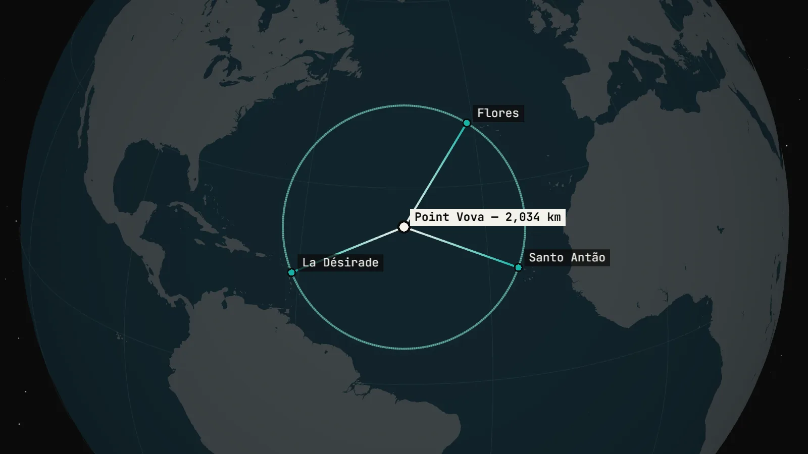
My result is 24.1852° N, 43.3709° W. That is about 50 metres from the coordinates Barnes published in 2019.
I wondered where those 50 metres came from, since both calculations use OpenStreetMap and the same ellipsoid.
There could be two reasons: either the map itself changed over the years, or Barnes and I calculate differently. To tell them apart, I computed the point once more, this time on a map nine years old. OpenStreetMap keeps the history of its edits, so the coastline can be taken as it was on 26 April 2017, the date of the map Barnes used.
It turned out to be both.
The map changed. On the old coastline my point came out 41 metres from where it is now. In nine years the coast of La Désirade was redrawn, and the spot on it nearest to the point moved by almost 600 metres.
And we do calculate differently. Even on the old map, Barnes’s point was still 31 metres away. It comes down to how the nearest shore is found. In Barnes’s paper it is chosen by straight-line distance, through the Earth, and only then measured along the surface. On a flattened Earth the shore nearest by straight line is not always the nearest along the surface. I repeated that method on the 2017 map and landed within 7 metres of Barnes’s point.
Together, 41 and 31 metres make 50, not 72: the two shifts point in different directions.
The gap is small anyway: against two thousand kilometres to land, the two points practically coincide. And far more interesting than the fifty metres is how much the result depends on a few small stretches of shore.
Above all on the rock off Flores.
It is so small that GSHHG doesn’t have it, yet it is the nearest land on the northern side. Leave out this rock alone, and the circle’s centre moves 16 metres. Leave out every rock smaller than half a hectare, and it moves 144 metres.
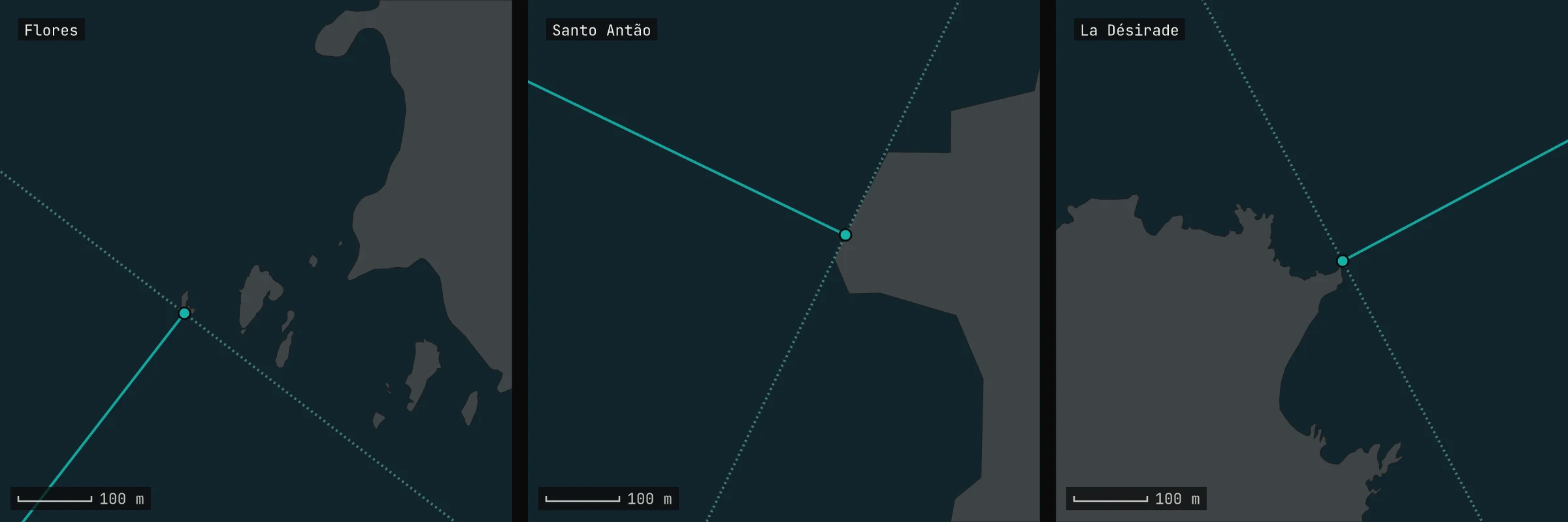
Satellite images confirm that all three points of contact fall on rocky shores. Of course, computing distances to the millimetre doesn’t mean the real shores are known that precisely.
Whichever small rocks I left out of the calculation, the centre stayed within about 150 metres. For a point in the middle of an ocean, that’s not bad at all.
With the names of such places, things are fairly free.
Names of geographical features on land are approved by states, and for undersea features there is an international procedure involving GEBCO. But a pole of inaccessibility is not an island, not a mountain, not even a physical object. It is a computed point on the surface of the high seas.
I found no body that officially gives names to points like this.
Point Nemo, for example, was named by Lukatela himself. There was no official ceremony; the name was simply a good one and it stuck.
So I decided to call the Atlantic pole Point Vova. Well, who’s going to stop me?
My part in it is modest. Barnes computed this point before me, and people knew how to find such places before him. I computed it again, from scratch and with a different, more precise algorithm, one that calculates the centre of the circle instead of searching for it. And I found what the point rests on: three shores, one of them a rock the size of a tennis court. I just found it funny that you can sit at home, look at a map, and then go and name a point in the middle of the Atlantic.
Now it has a name on at least one map.
Point Vova
Coordinates: 24.1852° N, 43.3709° W
In degrees, minutes and seconds: 24°11′07″ N, 43°22′15″ W
Distance to the nearest land: 2,033.9 km
Three nearest shores: Flores, Santo Antão, La Désirade
Stability of the coordinates: about 150 m
On the map: OpenStreetMap
By the way, the Indian Ocean has a pole of inaccessibility too. The nearest land is about 1,941 kilometres from it, and in the tables it is listed simply as Indian Ocean. The name is still free ;)
Data & caveats
- Code and data of the calculation: github.com/vova-today/point-vova, DOI 10.5281/zenodo.24369273.
- Coastline at the islands: OpenStreetMap (© OpenStreetMap contributors, ODbL), downloaded on 11 November 2026. For the comparison with Barnes: the same map as of 26 April 2017.
- Coastline of the rest of the world: GSHHG 2.3.7 (Paul Wessel and Walter Smith), full resolution.
- Distances on the WGS84 ellipsoid: GeographicLib 2.1 (Charles Karney, Algorithms for geodesics, 2013).
- The earlier calculation: Richard Barnes, Optimal orientations of discrete global grids and the Poles of Inaccessibility, International Journal of Digital Earth, 2019.
- Poles of inaccessibility on Wikipedia: Pole of inaccessibility (English) and Полюс недоступности (Russian).
- Point Nemo: Hrvoje Lukatela, Point Nemo, 2004, and Point Nemo, revisited, 2022. The year of the calculation, 2002, is Lukatela’s own. Wikipedia and the press give 1992: that is the year the coastline data he used came out.
- Depth: GEBCO 2020.
- Names of undersea features: IHO and IOC of UNESCO, publication B-6, section II.A.5.
- The high seas: UN Convention on the Law of the Sea, Article 89.
The point is computed from the coastlines as they were in November 2026. If a storm breaks up the rock off Flores or mappers redraw a cape, the point will move by tens of metres. The imagery shows that the shore is drawn correctly on the map, but not whether the rock off Flores goes under at the highest tide: if it does, the point moves by the same 16 metres.
How to cite
This format can be adapted for a report, research project or editorial feature built around your data.